


By: Steven Daun, National Chief Pilot
Weather is usually the weakest subject area that we fund when speaking with pilots. This is regardless of certificate or rating(s) held. The weather seems to be one of those areas that is treated differently than the other topics that we discuss. Why? The answer is usually that instructors have a weak understanding and, therefore, don’t want to risk getting into a difficult discussion. Because of this, pilots end up with a weak understanding as well.
Technology has not made this situation any better. In fact, in some ways, it has made it worse. When I started flying, you were able to walk into a Flight Service Station and stand face to face with a briefer. They would print out the charts and associated weather and show you what was happening. Asking questions only led to more education and, in turn, an increased understanding of what was happening.
Today, we find many pilots will either call Flight Service for a briefing or self-brief. However, rather than trying to understand and learn from what they are hearing or reading, they opt to somehow allow the briefer to make the decision for them. An example of this is a beautiful VFR Day with a thunderstorm 25 miles away. A briefer may say VFR is not recommended and people are ready to start canceling flights.
From time to time, you need to refresh your weather skills. We suggest keeping a copy of Aviation Weather and Aviation Weather Services in your physical or digital library. Refer to these on a regular basis to review what is available to you and how to use and interpret it.
This discussion is meant to remind you of the most basic weather concepts in hopes of motivating you to find out more about the weather, as well as encourage you to look further into the briefings that you receive. We are focusing on the weather systems north of the equator in this discussion. The “weather” consists of three factors. These include moisture, temperature and wind. As you consider your “go/no go” decision, you must consider all three factors and how they interact with one another.
These present themselves among other things in the form of pressure systems and fronts. Pressure on the Earth’s surface varies. Lower pressure areas often appear where the air is warmer. This is in part because of the rising warm air, which reduces the pressure on the Earth’s surface. Likewise, cooler air sinks, which generally increases the pressure on the Earth’s surface. Fronts are simply nothing more than boundaries between different air masses.
When we look at a low-pressure system, we know that the air mass in the center is lower in pressure than the air that surrounds it. As winds blow towards low-pressure areas, we see a rising of the warmer air. As the warmer air rises, the water molecules in the air condense, which forms clouds and possibly some sort of precipitation. The winds in a low-pressure system rotate in a counterclockwise direction or a “cyclonic” flow.
As we look at a high-pressure system, we know that the air mass in the center is higher in pressure than the air that surrounds it. This is in part because the cooler, denser air is increasing pressure on the Earth’s surface. Winds associated with a high-pressure system rotate in a clockwise direction or “anticyclonic” flow. These winds blow away from the high-pressure system as they sink down.
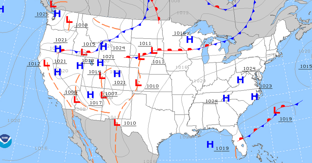
By this point, you should be able to look at the prog chart below and begin to formulate a visual in your head about the circulation of winds around the pressure systems. Part of this visualization should include your hypothesis on where you may find clouds and precipitation, as well as the general wind flow direction. This will also give you an idea of where the VFR and IFR weather is most likely to be found.
The next step is to look at the boundaries that separate each of these air masses. In other words, take a look at the fronts. There are four primary types of fronts that you need to understand: cold fronts, warm fronts, stationary fronts and occluded fronts.
![]()
A Cold Front forms when cold air moves under warmer air, usually in the form of a wedge. Since the colder air is denser (heavier) than the warm air, the warm air is forced upwards. As the warmer air rises, it cools and we see clouds forming with vertical development, which leads to precipitation and eventually turns into intense thunderstorms. The direction of the graphic depicts the direction of movement.
![]()
A Warm Front forms when warmer air moves into colder air. Because the warm air is less dense, it rises over the colder air. As this occurs, the warmer air is also pushing the colder air down towards and away from the Earth. As the warmer air rises, it begins to cool, thus creating clouds and widespread rain.
![]()
An Occluded Front forms when a cooler air mass overtakes a warmer air mass and the warmer air mass is then trapped between two cooler air masses. This forces the warmer air upward, resulting in clouds and precipitation.
![]()
A Stationary Front forms when a warm and cold front with equal strengths meet. Because they are of equal strength, they remain stationary. As the warm air condenses, it creates clouds and precipitation.
The weather briefer will give you information regarding advisories, forecasts, and observations. The advisories will be in the form of SIGMET’s, AIRMET’s or Center Weather Advisories.
The Forecasts will include things such as convective information, turbulence, icing, winds and temperatures, TAFs and Area Forecasts.
Observations will include METARs as well as ceilings and visibilities.
One hint that I have always found helpful is to print out the current prog chart and have it in front of me when I call for a briefing. This allows me to follow along with the briefer as they discuss current conditions and trends.
Once you understand the pressure systems and fronts, as well as their movement direction and speed, you can incorporate the rest of the briefing information into your analysis. You can then start to formulate a 3D visual of what will be happening along your route of flight.
With the availability of inflight weather, we are now able to continue to monitor the current and forecasted conditions which enable us to update our plan in real-time. This means that you shouldn’t just get your weather before you depart and forget about it. Keep yourself updated along your route of flight to ensure that
conditions aren’t changing from what you used to plan your flight.
If you are flying IFR, always find out where the nearest VFR is located. This becomes your escape route in case you have an inflight failure or emergency. Remember, it may be above, below, ahead, behind or to either side of your position. It’s better to be prepared and not need it than to need it and not know where the clear air is.